Commission Pages
- Victorian Local Government Grants Commission
- Financial Assistance Grants
- Consultation & Council Data
- Publications
- Local Roads Data Reconciliation Project
Local Roads Grants
As a component of the financial assistance grants provided by the Commonwealth Government, local roads grants are an important form of support for Victorian councils.
The Victorian Commission has historically recommended the allocation of these grants based on a formula that considers the length of local roads each council is responsible for, the traffic volumes carried on those roads, and various factors reflecting local characteristics, including climate and soil type conditions.
This methodology requires the annual collection of road length and traffic volume data from all councils. In addition to being a significant impost on councils, the Commission holds concerns about the robustness and consistency of the data provided.
Following extensive research and consideration, the Commission intends to move away from an allocation based on road length and traffic volume information provided directly by councils to one that draws on road length and road-purpose hierarchy data sourced from Vicmap.
This project will require a significant improvement in the accuracy of the local roads data held on Vicmap. However, it is anticipated that this work will deliver several major benefits. Councils will no longer be required to provide separate road length and annual traffic information to the Commission. Additionally, the project will provide higher quality and more accurate data for road users, including emergency services and the freight industry, as well as offering councils data to support asset reinstatement claims made after natural disaster events.
Local Roads Data Reconciliation Pilot
To support the transition to the new data collection method, the Commission recently completed the Local Roads Data Reconciliation pilot project. This project reconciles local road length data collected by councils for the Commission with corresponding local road length data in Vicmap.
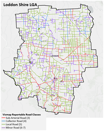
The pilot project, which involved five rural councils, was completed with significant success. Undertaken by Vicmap Spatial Services (VSS), it resulted in a data model that will assist in ensuring the consistency and reliability of the report metrics provided to the Commission on local roads. The data model is fully integrated with Vicmap through the Vicmap Transport (land.vic.gov.au) layer.
The pilot involved workshops with participating councils to reconcile their local road datasets with Vicmap’s dataset. It included a thorough analysis and a comprehensive consultation process with the councils involved.
Councils’ local road responsibilities were captured, and authority codes representing their ownership and responsibility within their municipality were assigned and added to the Vicmap Transport dataset. Using these assigned authority codes and additional analysis of segmentations and road naming conventions, Vicmap has extracted road lengths for council owned and responsible roads reportable to the Commission.
Many thanks to the five councils that agreed to participate in and complete this valuable pilot: Buloke, Loddon, Northern Grampians, Towong, and Yarriambiack.
Transition
Over the next three-four years, councils will work towards reconciling their roads data with the Vicmap database, which will become the data source for the Commission.
To assist councils in providing local roads data in this new format, a specific allocation from the local roads grant will be provided in the 2024-25 financial year for data support. This allocation is part of the total local roads grant pool and will be allocated based on a base amount of $10,000 per council, with the balance distributed in proportion to the total length of local roads in each council.
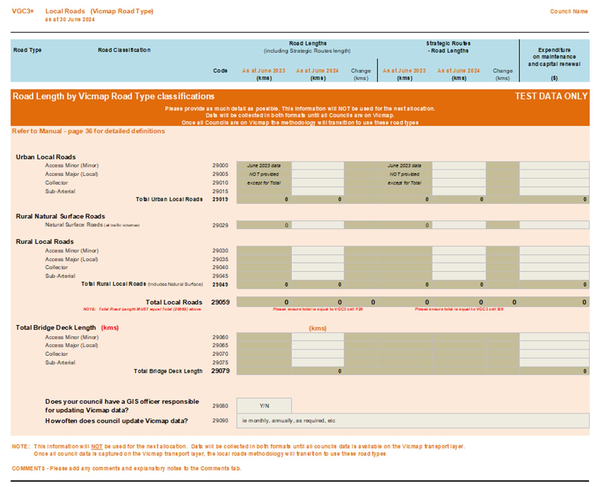
The allocation will assist all remaining councils to proceed to the first stage of the LRDRP. Each council will be asked to assign Vicmap authority codes according to an agreed road classification within the Vicmap Transport Layer and report this in the VLGGC Annual Data Return in a new tab – VGC3+.
VGC3+ allows for the collection of road classification data, including urban/rural splits and strategic routes in the Vicmap road classifications for local roads. Bridge data will also be collected in length of each road classification.

The data is requested to be categorised into urban/rural splits, strategic routes, and total maintenance expenditure.
Councils can elect which year of the next three-four years they wish to undertake their transfer and reconciliation process. The transition to Vicmap data will happen over a period of time, and it is expected that allocations will not be fully based on the new data sets until 2028.
In addition to eliminating the need for councils to complete local roads returns, this initiative will achieve a reliable and centralised local road data source for the entire state.

Information Session
Over 200 people attended the initial LRDRP information session held on 12 August 2024. The session provided councils with an overview of the pilot project undertaken and detail on the next steps for the provision of local roads data to be collected in the Vicmap transport layer.
Councils were informed of the data pack that will be provided to each council to assist them in the pre-work required before undertaking the reconciliation stage of the project with Vicmap Spatial Services (VSS).
The data pack includes:
- Vicmap road classifications for local roads PDF, 82.91 KB
- Vicmap road seal conditions and definitions XLSX, 11.74 KB
- Vicmap unique authority codes XLSX, 21.87 KB
- Vicmap road type abbreviations XLSX, 28.63 KB
- Geographic Naming Rules for places in Victoria 2022
- Q&A document providing basic information and more technical guidance PDF, 234.35 KB
- Full data pack (zipped) ZIP, 3836.24 KB
Several meetings and consultations with council have taken place during 2025. This presentation PDF, 2027.73 KB provides a summary of key discussion points and information regarding the requirements for the LRDRP.
Next Steps
VGC3+
- Review local road data set and include Vicmap roads classifications (3-6) on all council local roads for VGC3+
- Provide as much detail as possible in VGC3+ including any information in the comments section before the submission of the Commission’s Questionnaire on 5 November 2025.
Vicmap
Vicmap is currently monitoring requirements to populate aspatial data fields listed below in the Vicmap Transport (TR_ROAD) dataset using information provided by Victorian councils.
Based on council capacity, extract and review aspatial attributions in the Vicmap Transport (TR_ROAD) dataset including fields below and then provide as a bulk upload (preferably in shape file format) to the Vicmap Editing Service (VES) and quote “LRDRP”:
- Vicmap Road name (ROAD_NAME)
- Vicmap Road Type (ROAD_TYPE)
- Vicmap Coordinating Authority Code and
- Vicmap Responsible Authority Code Allocation (Talk to your neighbouring councils and agree on border responsibilities and representation)
The following spatial fields were also identified as being crucial for future road length reporting as a part of VGC3+. Vicmap is currently reviewing requirements to uptake in the TR_ROAD dataset.
- Vicmap Road Classification Code (CLASS_CODE)
- Vicmap Road Seal (sealed, Unsealed, Unknown, Natural) (ROAD_SEAL)
Please note: Vicmap Road Classification Codes and Vicmap Road Seals will not be uploaded to Vicmap TR_ROAD at this time, Vicmap continues to investigate requirements to upload these attributes.
If you would like assistance with Vicmap Editing Service (VES) or require an account with VES please email vicmap.help@transport.vic.gov.au (and quote the LRDRP)
Contact us
Should you have any enquiries regarding the initial stages of this project and current updates, please contact Commission staff - Julia Keeble julia.keeble@dgs.vic.gov.au
If you have Vicmap related queries please email Vicmap Program Contact - Aastha Sharma at vicmap.help@transport.vic.gov.au